 |
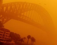
Wellington (AFP) Sept 25, 2009 Particles from the dust storm that engulfed parts of eastern Australia this week were detected 2,150 kilometres (1,335 miles) away across the Tasman Sea Friday, raining down on New Zealand. Meteorologist Philip Duncan of the WeatherWatch website said orange dust falls had been reported in the North Island districts of Auckland, Northland, Waikato, Bay of Plenty and Taranaki. Weather forecasters had tracked the dust storm in satellite images as it crossed the Tasman riding on a swirling low pressure system that brought bad weather to most of New Zealand. It was clearly visible where it landed, particularly on car windows. "It arrived yesterday afternoon but was caught up in the rain and cloud associated with the front. Now that the skies are clearing it's quite evident," Duncan said. A Taranaki resident told the website the dust was so thick at the school where he worked it would not wash away in heavy showers. "We have flat roofs on the buildings that are normally silver but this morning they were covered in a burnt orange very fine silt, that accumulated to approx two millimetres in places with the run off from the rain". Tadhg O'Loingsigh, from the school of geography at Monash University in Melbourne, Australia, said his team hoped to "fingerprint" the dust by analysing its minerals. "If we can fingerprint it, we can trace where it came from," he said. Although it is not unusual for smoke particles to cross the Tasman, meteorologists said the arrival of Australian dust was a rare occurrence. At its peak in Sydney, the dust storm forced airlines to cancel several trans-Tasman flights from New Zealand.
earlier related report Howling winds pushed the 200-kilometre (125-mile) wide cloud of desert dust through Sydney and up the coast to Brisbane, prompting a rash of emergency calls as residents choked on gritty air. While Sydney's early-morning visibility was sharply reduced, the storm did not approach Wednesday's doomsday situation, when the city awoke to an unearthly red glow and was coated with a fine layer of grit. Satellite pictures showed the thick band of dust sweeping from central Australia towards the east coast, with visibility in Sydney limited to five kilometres, said forecaster Barry Hanstrum. "We've got an area of widespread dust but not as thick as it was on Wednesday," said Hanstrum. Sydney's air quickly cleared in blustery conditions as the storm headed north. However, emergency services registered a sharp increase in call-outs for people with breathing problems. "Thankfully, it's not as busy as it was on Wednesday with the amount of dust that has been around," Sydney paramedic David Morris told public broadcaster ABC. "But between seven and eight o'clock this morning we still had double our jobs for breathing problems compared to yesterday," he said. Wednesday's storm, which was visible from space and left hundreds of people needing treatment for breathing problems, was reportedly Australia's worst in 70 years. The storm was estimated to have dumped millions of tonnes of dust on the east coast with particles later landing in New Zealand -- around 4,000 kilometres away over the Tasman Sea. Weather bureau forecaster Jane Golding said it was extremely rare to see two large dust clouds so close together. "(It would be) be pretty unusual if we get another one any time soon," she told ABC. The storms have been whipped up by strong winds following the hottest August on record, gathering dust left by southeastern Australia's crippling, decade-long drought. Residents of Young, west of Sydney, said plumes of dust whirled through the country town early on Saturday. "Standing outside my place now looking at the clock tower, it's about half a kilometre away. You can just see it, with the thickness of it, you can just see the town lights," said Young resident B.J. Wyse. "It's just like a red glow. I just talked to a friend of mine in Cootamundra and it's going through there as well, so yep, it's back again," he told state radio. Saturday's storm hit with residents still clearing their homes and cars after the first, and as Queensland state firefighters battle a number of bush blazes. Share This Article With Planet Earth
Related Links Farming Today - Suppliers and Technology
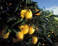 New agriculture computing tool created
London (UPI) Sep 23, 2009 British scientists say they have developed a new computing tool that can predict how plants will react to various environmental conditions. Imperial College London researchers say their new computer program could lead to better crops, such as tastier and longer lasting tomatoes, as well as more effective pesticides. The tool will form part of a new $2.7 million Syngenta Center at ... read more |
|
| The content herein, unless otherwise known to be public domain, are Copyright 1995-2009 - SpaceDaily. AFP and UPI Wire Stories are copyright Agence France-Presse and United Press International. ESA Portal Reports are copyright European Space Agency. All NASA sourced material is public domain. Additional copyrights may apply in whole or part to other bona fide parties. Advertising does not imply endorsement,agreement or approval of any opinions, statements or information provided by SpaceDaily on any Web page published or hosted by SpaceDaily. Privacy Statement |
 del.icio.us
 Digg
Digg Reddit
 YahooMyWeb
 Google